Tuesday, April 30, 2013

Today felt like summer!

Current conditions

Temperature: 73°F
Wind: 19 mph from the WNW (gusts up to 25)
Pressure: 29.71 in
Humidity: 34%
Dew Point: 43°F

Here we can see the low pressure systems associated with the "Winter Storm Achilles." Our weakness is that we celebrated the weather too soon? This is just another piece of evidence that weather can change when you least expect it. A week ago we were talking about how we were finally moving into spring and summer and now this.

The dip in the jet is getting more pronounced even just compared to yesterday's forecast from Intellicast. It looks like we are in for cold temperatures over the next few days and through the end of the week.


This surface data map is interesting because the wind in our area is coming from the WNW but the surrounding winds are coming more from the southwest to our east. However, I suppose the winds in Minnesota are also coming more from the North. This further suggests that a storm is moving our way from the West.

Monday, April 29, 2013

 Current conditions

Temperature: 72°F
Wind: 12 mph from the SSE
Pressure: 29.64 in
Humidity: 49%
Dew Point: 52°F

 You can see what looks like a trough to the northwest of us - possibly coming our way?
Here is the surface data - it is mostly overcast here now. You can see the wind direction from the southeast.

Tomorrow is supposed to be just about the same as today. What I am worried about is this talk of snow on Thursday...

Saturday, April 27, 2013

I'm in Minnesota for the weekend and it has been gorgeous outside. T-shirt weather is something I can get used to. As usual I'll still give the weather for Eau Claire.

Current conditions

Temperature: 63°F
Wind: calm
Pressure: 30.1 in
Humidity: 56%
Dew Point: 47°F

As you can see from the surface data the skies are clear over our area and the wind is very calm.


Tomorrow is supposed to get up into the mid 70s and clear skies.

Wednesday, April 24, 2013

Today is gorgeous. It's been clear all day and really sunny - just a little windy is all.


Current conditions

Temperature: 51°F
Wind: 20 mph from the SW (with gusts up to 29)
Pressure: 29.92 in
Humidity: 31%
Dew Point: 21°F

 Here is the current surface map, another high pressure system is moving our way.

And here is the jet stream forecast - you can see the streak has moved a bit from yesterday.

Lastly, here is the surface data as of 4 pm. You can see the wind coming from the south west, as well as the cloud cover - fairly clear over our area.

Tonight is where the rain comes in that was predicted yesterday. I thought maybe it was also during the day but it turns out it should start at about 9 or 10 pm.

Tuesday, April 23, 2013

So I missed all of these past couple weeks..where we kept being teased by spring and ending up right back in winter. Maybe I was trying to deny it's existence by not blogging about it, I don't know. But I'm back. And spring is coming and it's for real this time!

This is a photo I snapped while walking home this evening. It was the first time the sky had been clear on a walk home in what felt like forever.


Current conditions

Temperature: 33°F
Wind: 5 mph from the W (yay!)
Pressure: 30.02 in and rising
Humidity: 64%
Dew Point: 22°F

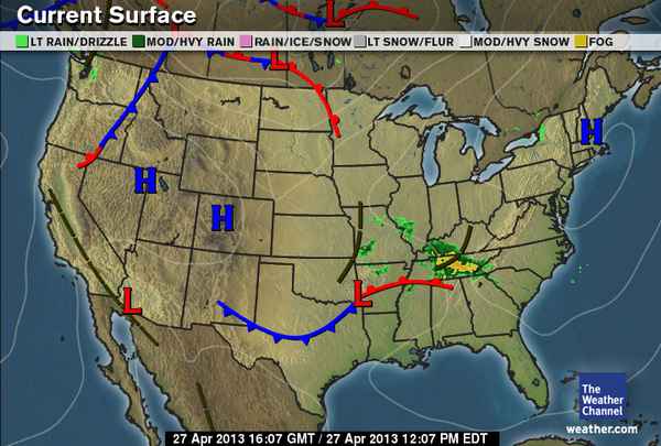
 This is the current surface map: there's the precipitation moving east away from us as we discussed in class this morning. This makes way for what should be constant high pressure clear weather conditions.

Here is the jet stream forecast for tomorrow. We are in a trough but that should move so that we are on a ridge - that foreign word.

The forecast for tomorrow calls for rain however, so those clear skies might have to wait a couple days more.

Thursday, April 11, 2013

 Wintry mix. That's what we're in for today.

Current conditions

Temperature: 34°F
Wind: 14 mph from the ENE
Pressure: 29.77 in
Humidity: 89%
Dew Point: 31°F

I thought that this temperature map was interesting to note because it is cold almost everywhere in the United States. Only Florida and the area of the Carolinas seem to be escaping the cold temps.

The water vapor is in the same places as the precipitation on the surface map.

 The dip in the jet stream seems to be in about the same place as yesterday. However, now there is a streak over our area which would indicate stronger winds.
The cloud cover is overcast due to the precipitation which makes sense. The wind direction looks to be prevailing from the Southeast.

Wednesday, April 10, 2013

Plenty of people had a lot to say about the weather when they woke up this morning - myself included. I couldn't help but send a disgruntled tweet of my own. There was a few inches of snow on the ground. The rain from yesterday turned into snow overnight as the temperature fell.

Current conditions

Temperature: 38°F
Wind: 8 mph from the ENE
Pressure: 29.94 in
Humidity: 64%
Dew Point: 27°F

 The surface map doesn't show precipitation near us even though we are technically in a winter storm warning until tomorrow at 7 p.m. The more interesting action looks to be in the East, where the dip in the jet is moving.

The jet stream is crazy looking - you can see the strong dip in the middle of the United States which will continue to move to the East. Weather.com reporters are predicting possible tornadoes and thunderstorms, but most importantly are the damaging winds.

Saturday, April 6, 2013

Last night there was an interesting mix of snow and rain. Today has been dreary and dark and there is a chance for rain later this evening.

Current conditions

Temperature: 46°F
Wind: 11 mph from the SSE
Pressure: 29.58 in
Humidity: 56%
Dew Point: 31°F

 You can see the precipitation on the map in eastern Minnesota - likely the same system that will be moving our way later on today. The low pressure front is the cause of this weather.

The cloud cover is pretty consistent over eastern Minnesota and western Wisconsin - overcast due to the precipitation. The prevailing winds are coming from the Southeast and you can make out the mid latitude cyclone where the winds shift and turn in a counterclockwise manner.

The jet is pretty flattened out without much to bring attention to except possibly right next to Florida.
There is a tornado warning through next week due to some warm moist air coming up through Texas and Oklahoma. The most we would be affected up in Wisconsin is some higher possibilities for thunderstorms.

Tuesday, April 2, 2013

Today was more of the same..a few cumulus clouds here and there. I found it particularly chilly today with the wind.


Current conditions

Temperature: 29°F
Wind: 6 mph from the WSW
Pressure: 30.28 in
Humidity: 52%
Dew Point: 17°F

 We are still in an area of high pressure.

As you can see in the area of the high here in the Midwest the cloud cover is basically nonexistent. Just another reason for the lack of precipitation.

Tomorrow should hopefully reach up into the 40s during the day for a high - it will most likely be clear again with decent wind speed.

Monday, April 1, 2013

Easter weekend was very nice - even grilled some venison brats on Saturday. Today, back in Eau Claire it is a bit chilly just as was predicted for the beginning of this week. However, the sun is shining. I saw some puffy cumulus clouds although they were pretty sparse since it's a mostly sunny day.

Current conditions

Temperature: 28°F
Wind: 15 mph from the West
Pressure: 30.17 in and dropping
Humidity: 45%
Dew Point: 13°F

 Very interesting weather pattern. We are definitely experiencing typical weather associated with an area of high pressure. The isobars are not too close which also explains why the wind isn't too strong either.

Looking at the jet stream you can see that we have some colder weather coming through the area from Canada. I am curious as to what that blurb is over central California (I have no idea)